
We previously introduced our draft Transit-Enhanced Network and plans for pedestrian enhancements. Here’s our proposal for the draft Bicycle-Enhanced Network. We are asking you to tell us if the candidate streets should receive enhancements or if a different street should be chosen for enhancements. Take our draft Bicycle-Enhanced Network Survey here.
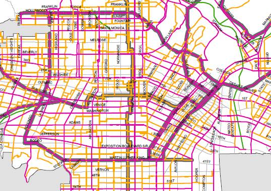
Click on the image for the full Bicycle-Enhanced Network.
Our outreach participants consistently cited safety concerns as the primary deterrent to bicycling in Los Angeles. Although our city has a climate and topography suited for bicycle trips, many worry about compromising their safety due to high vehicle speeds and the lack of protected bicycle lanes and connecting routes. High vehicle speed is not only a major deterrent for bicyclists of all abilities, but also increases the likelihood of more severe injury or fatality during collisions.
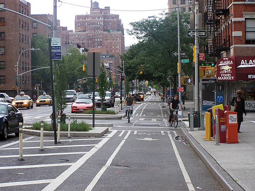
We want to bring cycle tracks, like the one shown here on New York City’s Ninth Avenue, to Los Angeles. Where should the first one be? Photo Credit: Beyond DC/Streetsblog DC
In order to fulfill our Mobility Element goals and achieve complete streets, we recognize that the City needs to create a network of comfortable, safe on-street bicycle facilities that will reach local and regional destinations for all types of bicyclists. The City’s 2010 Bicycle Plan set the groundwork for creating a bicycle-friendly Los Angeles and improving safety for all roadway users. The update of the Mobility Element provides an opportunity to further identify facilities for implementing buffered or protected bicycle facilities that could encourage Angelenos aged 8 to 80 to cycle to their destinations.
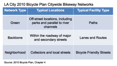
We want to build upon the Backbone and Neighborhood Networks to bring desirable aspects of the Green Network (like buffering from vehicles and exclusive spaces for bikes) to our streets.
We took a stab at a first draft of a more robust bicycle network by building off of the City’s Bicycle Plan. What’s available now for review and discussion is what we’re calling the draft Bicycle-Enhanced Network, a 120-mile subset of the streets on the 2010 Plan’s Backbone and Neighborhood Bikeway Networks. The new bicycle-enhanced streets will work in conjunction with existing paths and lanes to provide a network of bikeways for all types of riders. The rest of the facilities designated on the Networks will be implemented as envisioned by the Plan, but the enhanced streets will receive treatments beyond a regular bicycle lane or shared lane marking (sharrow). The majority of the bicycle-enhanced streets are major streets on the Backbone Network, but in some locations, streets on the Neighborhood Network were chosen as better candidates when there was a conflict with other modes that could not be resolved.
Similarly to the Transit-Enhanced Network, improvements along the Bicycle-Enhanced Network would primarily consist of:
- Right-of-way infrastructure improvements: Bicycle-Enhanced Network streets may receive treatments within the rights-of-way of major streets to allow for exclusive traveling space for bicyclists. Neighborhood streets that are enhanced may receive traffic diversion treatments, which are not only safer for bicyclists but also achieves traffic calming goals and reduces cut-through traffic. The type of considerations, such as buffered or protected bicycle facilities, will be determined upon further community outreach and analysis.
- Signal timing infrastructure improvements: Bicycle-Enhanced Network streets may also receive signal timing features that benefit bicyclists, such as bicycle signals, bike detectors, or separate signal phases.
- End of trip facilities: Regional, community, and neighborhood centers and destinations along the Bicycle-Enhanced Network may receive end-of-trip facilities to improve travel for new and experienced bicyclists. Examples of these facilities include long-term and short-term bicycle parking, showers, lockers, mobility hubs and repair stations.
CANDIDATE STREET SELECTION
The streets of the Bicycle-Enhanced Network were selected based upon the following criteria:
- Connectivity between regional centers and major destinations
- Higher presence of bicyclists through bicycle counts
- Higher presence of collisions involving bicyclists
- Designation within the Backbone or Neighborhood Networks in the 2010 Bicycle Plan.
Sample Enhancements on the Bicycle Enhanced Network:
In addition to standard wayfinding and street markings, the Backbone Network streets selected for enhancements may receive a selection of treatments listed below. These treatments are explained in further detail in the 2010 Bicycle Plan’s Technical Design Handbook (TDH), except where noted.
- Wide Bicycle Lane with Additional Pavement Markings (9.1 TDH);
- Raised Bicycle Lanes (9.12 TDH);
- Cycle Tracks-Protected Bicycle Lanes (9.13 TDH); or
- Dedicated Bicycle Lane w/Bus Lane (3.5 TDH may be modified to have a curb-adjacent bicycle lane with passenger crossing markings and boarding platform).
In addition, an assortment of additional treatments could include:
- Colored Bicycle Lanes in Conflict Areas (9.6 TDH);
- Colored Bicycle Lanes at Interchanges (9.7 TDH);
- Bicycle Box (9.8 or 9.11 TDH);
- Two Stage Turn Queue Boxes (NACTO).
The Neighborhood Network streets selected for enhancements would be designed to a “Bicycle Friendly Street Level 5” designation, which could include:
- Mini-roundabouts (4.6 TDH);
- Stop Signs on Cross-Streets (4.7 TDH);
- Curb Bulbouts and High-Visibility Crosswalks (4.8 TDH);
- Diagonal Diverter (4.9 TDH);
- Bicycle Signals at Major Intersection Crossings (4.10 TDH);
- Crossing Islands (4.11 TDH); or
- Bicycle Only Left Turn Pocket (9.4 TDH).
Here’s the complete list of streets we want you to consider. Each corridor is envisioned to provide local and regional connections between neighborhoods. Launch a map of the network here (PDF, Google) and take our survey here.
Corridors
Atwater Village to Downtown, via Fletcher Dr, Glendale Blvd, and Second St
Brentwood to Venice, via San Vicente Blvd and Barrington Ave
Coastal Bike Path to Marina Bike Path, via Washington Blvd
Downtown LA, via Figueroa St & Flower St Couplet, Spring St & Main St Couplet, Seventh St
Hollywood to El Sereno, via Hollywood Blvd, Sunset Blvd, Cesar Chavez Ave, Mission Rd, and Huntington Dr
Hollywood to West Adams, via La Brea Blvd and Redondo Blvd
Los Feliz to Harbor Gateway, via Edgemont Ave, Melrose Ave, Heliotrope Dr, Rosewood Ave, New Hampshire Ave, James M Wood Blvd, Catalina St, San Marino St, Berendo St, Twelfth St, Catalina St, Fifteenth St, Berendo St, Catalina St, Budlong Ave, 36th Pl, Catalina St, Budlong Ave, 60th Pl, Vermont Ave
Mid City Connection, via San Vicente Blvd
Northeast LA, via Colorado Blvd, Figueroa St, Cypress Ave, and Eagle Rock Blvd
Northeast Valley to Sherman Oaks, via Van Nuys Blvd
Sun Valley to North Hollywood, via Lankershim Blvd
Venice to Downtown, via Venice Blvd, 4th Ave, Country Club Drive, St Andrews Pl and Eleventh St
West Adams to Vernon Central, via Rodeo Rd and Martin Luther King, Jr. Blvd
Westchester to South LA, via Manchester Ave
Westwood to West LA, via Westwood Blvd


Pingback: Your big, bold list of King/Inauguration Day bike links « BikingInLA
Do you really think that Hollywood Blvd. is the best east-west street in Hollywood? The street is one of the few in LA designed for the pedestrian’s pace. Drivers rubberneck, look for parking, plus there are several buses, at least east of La Brea. I think that between Gower and La Brea the east-west lane should shift to Sunset.
Reblogged this on LADOT Bike Blog and commented:
LA City Planning had a great post last week about its draft Bicycle-Enhanced Network plan. Check it out below if you’re interested in what enhancements will be hitting the streets of Los Angeles in coming years.
So why is the entire West Valley, as well as the harbor areas, excluded?
We decided to keep the West Valley and Harbor area streets as planned for in the 2010 Bicycle Plan (instead of cycle track treatments, we are considering keeping regular bike lanes and bicycle-friendly streets). Many of the West Valley and Harbor area streets have lower traffic volumes (http://bit.ly/WCab9S), which, typically can be more comfortable for riding. Are there streets in the West Valley and Harbor areas in the 2010 Bicycle Plan that should be elevated to have cycle tracks?
I live in West LA and I want to make a point about Westwood Boulevard. Of course bike trips need to be encouraged, especially with the advent of EXPO and it’s potential to connect to UCLA but you cannot take away a parking lane on Westwood Boulevard to accomodate a bike lane in my opinion. Business have a hard time already and unless the City wants to spend some big bucks to build some parking structures, taking away a parking lane would be the end of the many small businesses that face onto Westwood Boulevard. Westwood is only so wide so when considering where this potential new lane should go I hope the planners and the community remember all of the Mom and Pops on the street and how they contribute to our community every day.
I agree, plus its not guaranteed that people will actually choose to bike rather than drive. Would be a shame if that parkings are eliminated for a small trickle of bike riders
Doesn’t seem like an accurate map. I believe that Vineland Avenue in the San Fernando Valley has a way more extended bicycle path than what is show on this diagram.
This is excellent news– yes we need a citywide network of cycle tracks if LA ever hopes to achieve a high bicycle mode-share that is safe, comfortable, convenient, and pleasant for all ages and abilities. Because I am most familiar with Northeast LA, I would like to comment on the proposed network of cycle tracks for that area.
Firstly, I’m sure the selection process wasn’t very difficult. As anyone familiar with Northeast LA knows, due to the topography of the area the flattest (and usually most direct) routes between destinations within the neighborhood tend to be the main, commercial streets. As a result, it is absolutely necessary that NELA’s main streets be safe and comfortable for cycling. Oftentimes the main streets are the only viable option for cycling since traversing more hilly, adjacent streets is more challenging on a bicycle (especially for children and the elderly). When it comes to North Figueroa, there is absolutely no alternative parallel street to use as an alternative so thank you for being aware of this and recognizing the need for enhanced – hopefully cycle tracks – bicycle infrastructure along these streets.
Secondly, providing anything less than cycle tracks on Eagle Rock Boulevard and Colorado Boulevard is not going to encourage mass cycling since these streets are enormously wide and uncomfortable for cycling without any kind of physical barrier protection. Careful consideration to design will be necessary on Eagle Rock Boulevard where it intersects with the 2 freeway entrance/exit and on Colorado Boulevard where it meets with the 134 entrance/exit. Perhaps separate signal phases can reduce potential for conflict between cyclists and motorists at these sections. Also as stated above, North Figueroa Street while not as wide as Eagle Rock or Colorado Boulevard lacks any kind of parallel street that a cyclist could use as an alternative. This is especially true north of York Boulevard. While North Figueroa may be more residential in character north of York Boulevard it is still suitable for cycle tracks precisely because there is no parallel alternative streets to use. The street is even adjacent to several schools (an elementary school, two middle schools, and a high school) making the case for cycle tracks even more compelling. As for Cypress Avenue: it would appear based on everyday experience that even with the existing bike lanes that the lanes could be widened and converted to cycle tracks by reallocating street-space since the street currently sees such low traffic volumes, even during rush hour.
Also due to the unique geography and street layout of Northeast LA, there will fortunately be opportunities to further enhance the proposed cycle track routes to make cycling faster than motorized travel. Allow me explain: in Northeast LA, especially on Colorado Boulevard and North Figueroa Street, there are a lot of T-intersections that could conceivably allow cyclists to bypass red lights currently in place for motorists. One example where this could work is for northbound bicycle traffic on Figueroa where the street intersects with Yosemite Drive. When looking at the street one notices that pedestrians on the eastern sidewalk are not stopped by the red light on Figueroa if Yosemite has a green light. This is because there’s no conflict with the pedestrian’s movement and traffic on Yosemite– the same would be true for bicycle traffic if cycle tracks are implemented. It’s a small measure but when one adds up all the intersections where cyclists could conceivably bypass red lights it’ll make a huge difference in how competitive the bicycle is as a mode of transportation.
Another T-intersection where cyclists could conceivably bypass the red phase without compromising safety is at the signalized intersection of Colorado Boulevard and College View Avenue. Here eastbound traffic could completely bypass the red phase as pedestrians do and it would my cycling that much more convenient. Though this intersection falls outside of the proposed enhanced bicycle route for Colorado Boulevard, it’s a worthy investment that should be considered at all T-intersections where we hope to see cycle tracks in the future.
Now if I may, I would like to make a couple additional comments regarding the proposed enhanced cycle routes:
I strongly feel there should be proposed cycle tracks to bring cyclists of Northeast LA into Downtown LA or into Lincoln Heights, otherwise NELA’s cycle tracks simply go in a loop or go into Atwater Village. Why not make, for example, a combination of Pasadena Avenue and Daly Street part of the enhanced cycle track network? Then cyclists could take that route and connect to the proposed cycle track on Mission Road and the enhanced cycle routes would form more of a network than mere segments of comfortable cycling.
Also, is there a reason why Broadway in Lincoln Heights is not part of the proposed cycle track network? Perhaps there could be an enhanced route taking Broadway in Lincoln Heights that then continues on Spring Street and takes cyclists into Chinatown and Downtown LA.
I’d also like to point out that cyclists traveling southeast on Cypress Avenue should be able to continue on a protected cycle track where the street splits and leads traffic onto Avenue 28. Perhaps this can be added in tandem with extending the proposed enhanced route on North Figueroa south by two blocks so that there can be cycle tracks all the way to Avenue 28. It would actually be great if the enhanced cycle route for North Figueroa extended south all the way to the LA River Path to take advantage of the regional connectivity that facility provides. It doesn’t seem for there to be any reason to terminate a comfortable cycling facility at Cypress Avenue when it could connect to the LA River.
I appreciate the efforts of the planning department but I feel more attention could be paid to make the proposed routes more of a cohesive network. It would be fantastic to see Lincoln Heights and Northeast LA connected by cycle tracks. Lastly, when it comes to intersections it’s my hope that we can go Dutch– any bicycle planner will admit the Dutch have perfected intersection design for cyclists and it would be foolish to not follow their excellent model for intersection treatment.
Thank you for looking to make bicycling a desirable, viable, safe, and comfortable mode of transportation.
I just looked that PDF for the draft Bicycle-Enhanced Network and it says to leave feedback in the townhall– is it okay for us to leave feedback in the comments of this blog post as well? I would have left my comment in the townhall but the character constraint means I would need to leave 2 or 3 comments.
Thanks!
Yes, leaving your comments on this blog post is perfectly fine. We are taking these comments into consideration also. Thanks!
Thanks for the clarification, and thanks for taking all comments, whether in the town hall portion or in these posts.
Installing a unprotected buffered bike lane on a busy street that has high-speed traffic would not lower the stress-level enough to be a very appealing street for the traffic-intolerant bicycle rider. There needs to be a physical barrier between the bicycle rider and motorized traffic on these streets in order to attract a large proportion of the population to bicycle there.
There can be physical barriers that reduce the choice of through streets that would get the bicycle rider past them. These barriers can be freeways, waterways, railroad right-of-ways and hills.
An alternative route for bicycling from UCLA to the future Expo Line station on Westwood Blvd would be to have a protected bike lane on Gayley Ave starting at Le Conte Ave and ending at Rochester Ave. Then make Midvale Ave bicycle friendly from Rochester Ave to Santa Monica Blvd. Make a bicycle only cut-through to connect Midvale Ave across Santa Monica Blvd. This would need dedicated bicycle signals. Continuing south, where Midvale Ave deadends at Pico Blvd have either a protected bike lane on Pico Blvd to connect to Westwood Blvd, or have the bicyclists ride a short distance on the sidewalks. Then, have a protected bike lane on Westwood Blvd from Pico Blvd to the Expo Line. Unfortunately, there is no reasonable alternative to using Westwood Blvd from Pico Blvd to the Expo Line for bicycle infrastructure.
The amount of traffic Barrington Ave would require a barrier protected bike lane to make it comfortable enough to bicycle for the masses. Each protected bike lane would need to have a five-foot bike lane plus a 3-foot buffer for a total of 16-feet wide. This would necessitate the removal of parking on both sides of the street or remove parking on one side of the street and make it a one-way street for motorized traffic.
An alternative to using Barrington Ave from San Vicente to the Expo Line Station would be to make Westgate Ave bicycle friendly from San Vicente Ave to Wilshire Blvd. Then connect the bicycle rider to Armacost Ave on the south side of Wilshire Blvd via way of the sidewalk and dedicated bicycle signals. Direct the bicyclist west on Mississippi Ave to protected bike lanes on Bundy Dr to connect to the Expo Line Station and get past the physical barriers of the Expo Line and the I-10 freeway.
There is no practical alternative to using either Bundy Dr or Barrington Ave for bicycle infrastructure from the I-10 freeway south to Venice Blvd. The alternative routes would be too far from the most direct path and therefore would be very unappealing.
To connect UCLA employees to the city of Santa Monica there needs to be a protected bike lane along busy Ohio Ave to get past the physical barrier of the I-405 freeway. The alternative choices of Sunset Blvd, Wilshire Blvd or Santa Monica Blvd are all much more difficult to make comfortable enough to ride for the majority of the population. Ohio Ave would probably need to be made a one-way street to create enough room for protected bike lanes on both sides of the street. Without a protected bike lane to get past the I-405, the rate of cycling will be limited to a small proportion of the adult population that that east/west in the area.
Pingback: Task Force Meeting Update | LA/2B
Like Linnea, I’m not certain that Hollywood Blvd is the best option for an east-west street through Hollywood, but it might be. At any rate, whatever east-west street is chosen through this area (whether Hollywood, Sunset, Fountain, or Santa Monica) it should connect to whatever plans the city of West Hollywood has, and the same with San Vicente. Ideally, these two parts of the network will intersect at Santa Monica and San Vicente, but this will need cooperation across cities.
There has to be something written into the planning code that would require the installation of barrier protected bike lanes in much the same way as sidewalks are required on both sides of a arterial street. Otherwise, a council member could opt out of installing bike lanes if constituents who drive complain about space being taken away from them to increase the safety of bicyclists.
Why is it that the public can prevent an increase in safety for bicycling on a street and yet they are not allowed to do that to pedestrians or motor vehicles? This seems to be a decision that is being made like we are in a collisium in ancient Rome, where the public is voting thumbs up or down whether a person gets maimed or killed. Some LA council members are deciding on this by which ever way the public votes. Since drivers are the majority and bicycling is a small minority, its rather obvious where the yes and no votes will be on this issue.